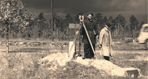
Establishment of the Warsaw Geodetic Company
On March 23rd, the National Council of Warsaw establishes the Municipal Geodetic Company. A year later, on April 19, 1951, MGC obtained legal personality and adopted the name Warsaw Geodetic Company (Warszawskie Przedsiębiorstwo Geodezyjne) which is still used today. At that time, the capital was rising from the rubble, and numerous, sometimes spectacular infrastructure investments were being carried out or planned. This required not only providing a qualified team of surveyors to handle these projects on an ongoing basis, but also performing titanic work to organize and improve the quality of the urban surveying resource. Meeting these challenges would not be possible without innovation and unconventional ideas.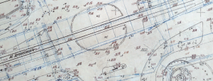
Inventorying of underground utilities
Underground utilities should be measured before it is covered up - today this principle seems obvious to surveyors and is of paramount importance to avoid collisions when laying new cables. But it wasn't always like that. For the first time such a legal solution came into force in Warsaw after a resolution of the Presidium of the Warsaw National Council came into force. One of the initiators of these regulations was WPG, and it is us who were initially responsible for mapping the land development in Warsaw. Thanks to the fact that the solution has worked, after some time similar rules have already become applicable throughout the country.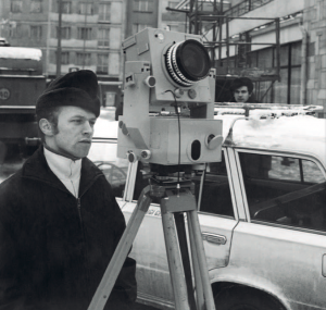
Establishment of a photogrammetry laboratory
The huge number of demolition and construction works that took place in the capital city required the use of methods to speed up the execution of surveying studies. In response to this need, the Photogrammetry Laboratory was established in WPG. Initially, it dealt with inventorying the facades on the basis of processed ground photographs; later it also carried out measurements of deformations of buildings. Over the years PL has specialised in the inventorying of monuments (from churches and castles to single sculptures), which remains our strength today. We've measured such unique objects in the capital as: The Royal Castle, Royal Łazienki Park, Wilanów Palace or Visitation Church. We also inventory monuments outside Warsaw. One of the first works of this kind was the measurement of huts in the Tatra valleys of Chochołowska and Kościeliska, commissioned by the Polish Tourist and Sightseeing Association for their maintenance. Later, we inventoried, among other things, the facades of historic tenement houses in Zamość. We successfully measure monuments also abroad. For the purposes of archaeological research of the Polish Academy of Sciences, we have inventoried the palace of a Roman governor in Paphos, Cyprus. What brought us many orders was also entering the laser scanning market. We have used this technology, for example, in measurements of the Paca Palace in Vilnius, the Berlin Opera House or the churches of the Linz diocese in Austria.Establishment of the first documentation reconciliation team in Poland
The simultaneous implementation of many investments inevitably led to chaos in the course of underground infrastructure. In order to prevent this from happening, on the initiative of WPG, the first Polish Team for Reconciliation of Engineering Structures Design Documentation was established, in which surveyors played a leading role. Over time, this idea has become acclaimed on a national scale as the so-called ZUD. Today it functions in a slightly changed form in the form of coordination meetings.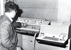
First computer in WPG
The WPG established the Electronic Computing Technology Team and installed the first computer. GEO-2 - as it was called - was used to calculate the surface areas and coordinates of parcels, allowing for significant time savings in the work related to the land and building register.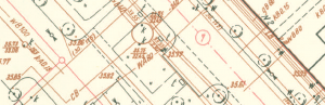
Introduction of maps in an overlay system
In Warsaw, the maps were made in various scales and standards, which poses numerous problems. In order to clean up this mess, the WPG has prepared and introduced "Rules of establishing and maintaining the map of the capital city of Warsaw", which later became the basis for the Instruction issued by the Chief Office of Geodesy and Cartography, applied throughout the country. It provides for two scales of the master map (1:500 and 1:1000) and a division into thematic layers. This can be treated as a kind of nucleus of the geographical information system (GIS) - a solution that was not popularized in the world until the end of the 20th century.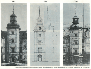
Rebuilding the Royal Castle
A decision is made to rebuild the Royal Castle in Warsaw. The photogrammetric reconstruction of the most characteristic element of this object, i.e. the Wladyslaw Tower, made by WPG, was of key importance during the design of these works. It was created on the basis of pre-war photographs of this building taken by tourists, among others. Today it is called crowdsourcing, but then it was pioneering work on a national scale, for which we received the "Cube" prize awarded by the Capital Association of Municipal Building Design.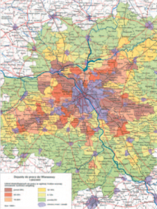
Start of work on the Warsaw Atlas
In Warsaw, the maps were made in various scales and standards, which poses numerous problems. In order to clean up this mess, the WPG has prepared and introduced "Rules of establishing and maintaining the map of the capital city of Warsaw", which later became the basis for the Instruction issued by the Chief Office of Geodesy and Cartography, applied throughout the country. It provides for two scales of the master map (1:500 and 1:1000) and a division into thematic layers. This can be treated as a kind of nucleus of the geographical information system (GIS) - a solution that was not popularized in the world until the end of the 20th century.WPG in Libya
A decision is made to rebuild the Royal Castle in Warsaw. The photogrammetric reconstruction of the most characteristic element of this object, i.e. the Wladyslaw Tower, made by WPG, was of key importance during the design of these works. It was created on the basis of pre-war photographs of this building taken by tourists, among others. Today it is called crowdsourcing, but then it was pioneering work on a national scale, for which we received the "Cube" prize awarded by the Capital Association of Municipal Building Design.Implementation of EWA system
The basis of any efficient economy is reliable and accurate land and building records. In order to speed up the modernisation of this important register, in cooperation with the Warsaw University of Technology we created and implemented the EWA 1 system for automatic update of the land and building register. The innovativeness of this undertaking has been appreciated by another "Cube" award in the history of our company. An upgraded EWA 2 system was implemented in WPG in 1989.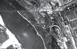
Construction of Toruń Route
The construction of Toruń Route is launched in Warsaw. For this project we used aerial photogrammetry for the first time. This reduced the cost of making a map for this route by 20%, while working time was reduced by 40%. Today, in the drone era, aerial photography is standard on any major investment.
Work for the Warsaw subway
The construction of the Warsaw subway is starting. The first surveying works for this project are being carried out by WPG in the 70s. The need for high accuracy required specific measurement methods. For example, we used electro-optical rangefinders for the first time in establishing the geodetic control network. At that time it was expensive equipment of considerable dimensions, today it is available to every surveyor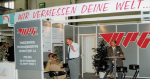
WPG for the first time at Intergeo
As a result of free market economic reforms, small surveying companies spring up on the Polish market like mushrooms after rain. In order to effectively fight the rapidly growing competition, you need to look for new business ideas and customers, also abroad. For this purpose, WPG decided to take part in the international Intergeo fair. In 1991 we were only visitors in Innsbruck, but two years later we had our own stand in Augsburg (as the first Polish geodetic company). Since then we have been an exhibitor at every edition of this event, which has resulted not only in many contacts but also contracts.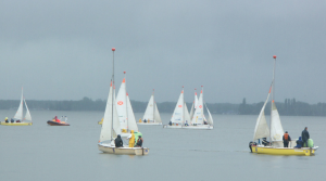
First regatta
In May 1992 WPG organized the first National Surveyors' Regatta in Lutry. In the following years WPG organized regatta on the Zegrzyński Lagoon. In 2010, more than 70 crews took part in the regatta.First numerical master map
Although in the age of geoportals a digital geodetic map seems ordinary, the first experiments in Poland in its development took place relatively recently, in the 1990s. One of the pioneers was WPG, where the first numerical master map was created in 1:500 scale for Warsaw's Wola district.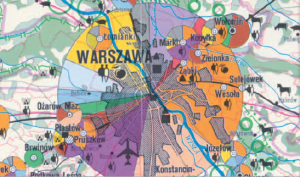
Development of the Warsaw Voivodeship Atlas
The "Warsaw Voivodeship Atlas" gets to bookstores - the only cartographic presentation of the region of this level of comprehensiveness to date. Several institutions were involved in the release of this work, including WPG. It consists of 120 colour maps presenting various thematic issues. The success of the atlas is best evidenced by the fact that the entire circulation was sold out shortly after its release.
Establishment of a joint stock company
Since 1989, WPG has undergone a number of reforms and reorganisations to adapt to the realities of the free market. Privatisation of the company is crucial. An important step towards it was taken on 9 November 1995, by setting up a joint stock company under the name of Warsaw Geodetic Company founded by 265 employees. On the same day, its statutes were adopted and the Supervisory Board was appointed. On April 14, 2000, a notarial deed was signed on the transfer of ownership of WPG from the State Treasury to shareholders. Privatisation was formally completed 6 years later, after the last capital instalment was paid to the Treasury.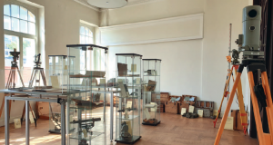
Establishment of the Museum of Geodesy
The rapid development of measurement technology makes our warehouses swell from old instruments, which are not lacking true rarities. In order to preserve at least some of them for posterity, we decide to establish the Museum Chamber. However, it soon turns out that it is not able to accommodate all items worth displaying. Therefore, a decision is made to establish the Geodetic Museum of WPG - the first such institution in the history of the country. The opening ceremony takes place on 14 December 2007.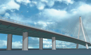
Construction of the Świętokrzyski Bridge
The construction of the Świętokrzyski Bridge is starting in Warsaw - comprehensive surveying services were provided by WPG. It was the first project for us in which we worked with the 3D model of the structure.
WPG S.A. participates in works on TBD
The Head Office of Geodesy and Cartography is launching a pilot project to replace paper topographic maps with a digital database, the so-called TBD. WPG not only participated in this innovative undertaking, but also took an active part in the production of TBD (later known as BDOT10k) and its update.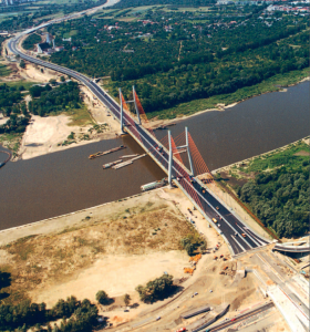
New technologies on the Siekierkowski Bridge construction site
The construction of the Warsaw's Siekierkowska Route begins - WPG couldn't have missed this project. This was the first project in which we used GPS-RTK satellite receivers allowing us to measure with centimetre accuracy in real time. Today, they are the equipment of almost every geodetic company, but at that time it was a complete novelty (and also very expensive), which excellently accelerated situation and altitude measurements and ranging. Moreover, the Siekierkowski Bridge was one of the first project in the country for which the so-called numerical ribbon map was developed - by WPG, of course.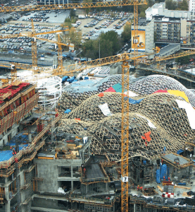
Construction of Złote Tarasy
In the shadow of the Palace of Culture and Science, the Złote Tarasy shopping centre is being built. At the construction site, all contractors and subcontractors (including WPG) must use a single database containing current digital designs for this project, which reduces the risk of errors and costly corrections. Today it is an obligatory element of BIM, i.e. modelling information about buildings, but at that time nobody has heard about this shortcut yet.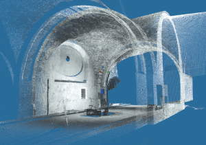
First use of laser scanner in WPG
In Arkady Kubickiego we conduct the first laser scanning in the history of our company (and one of the first in Poland). The work was a pilot, but a year later we received our first contract involving this technology. We used it to measure three rooms of the Royal Castle in Warsaw. At the time it was expensive and complicated, today it is much more accessible, so it is also used in smaller projects. Initially, the scanning was performed with a rented device, and since 2015 we possess our own devices.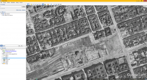
Orthophotomap of destroyed Warsaw
We are developing a map of the destruction of Warsaw based on aerial photographs of the capital from 1945. This project is a great way of showing how to take advantage of technological progress to breathe new life into old data and make it available to a wide audience in an attractive form. Our map can be admired today, among others, in the popular Google Earth application.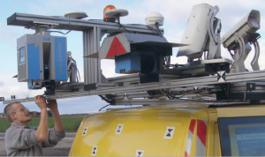
Mobile scanning of roadworks
The construction of the S8 expressway between Jeżewo and Białystok begins. During the surveying service of this route, we used mobile laser scanning for the first time, which allowed us to survey the project area quickly, in detail and without closing the traffic. The use of our own GPS reference station and the feeding of data into construction machinery control systems were also new to us.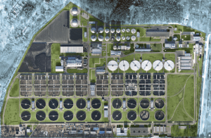
First orthophotomap from a drone in WPG
We performed an orthophotomap of the capital city's sewage treatment plant "Czajka" - this was probably the first study in the country based on drone photos for such a large project. We used them for the so-called duty map. Drones were a little known and underdeveloped technology in geodesy at the time, but we already felt how promising they were. Since 2019, we have had our own unmanned unit.
Introduction of radar interferometry technology
We are making our debut in space technology. Together with the Institute of Geodesy and Cartography and the Institute of Construction Technology, we are completing the three-year DefSAR project, which has allowed us to implement pioneering services of deformation testing with millimeter accuracy based on satellite radar imaging.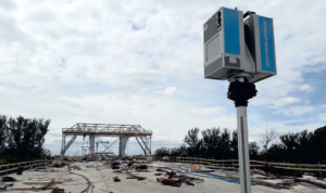
Construction of the Warsaw Southern Ring Road
The construction of Warsaw's southern ring road from Puławska Street through the bridge on the Vistula to "Lubelska" junction begins. While providing surveying services for 2 out of 3 sections of this project, we make extensive use of both laser scanning and drone-scanning. This confirms that we have correctly recognised the enormous potential of these technologies when they were still niche.
Sale of headquarters at 2 Nowy Świat Street
In September 2019, the Management Board of Warszawskie Przedsiębiorstwo Geodezyjne S.A. proceeded to sign the notarial deed of sale of real estate at 2 Nowy Świat Street in Warsaw. This building was the headquarters of the Company for almost 70 years.Purchase of new premises
Warszawskie Przedsiębiorstwo Geodezyjne S.A. purchased the building at 2 Biograficzna Street in the Warsaw Bielany district as the new seat of the Company. The building has undergone a general overhaul and adaptation for the Company's production needs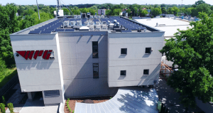
WPG in the new premises
On April 1, 2020 WPG S.A. moved to its new seat. It is a modern office building surrounded by greenery. For us it was a big change, because we have been using the previous seat since the establishment of the company, that is for exactly 70 years and 8 days.